Adept Enterprise ® - Planning Department Software as a Service
Adept Enterprise ® the advanced cloud computing service.
Planning and Zoning software as a service
The Adept Planning and Zoning module assigns, tracks and manages all
types of planning, zoning and engineering processes from the application
request to completion. Planning applications, land development and
design reviews, land use restrictions, historical preservation,
comprehensive plans and inspections are all managed with this application.
The Adept Planning and Zoning module
includes a work management Workflow
application shared by all users that keeps
track of activity status, work in progress and
schedules activities to the appropriate staff.
You can easily configure and assign a
workflow to all types of applications and
permit requests based on your specific
planning and zoning processes.
Timelines
inspections, fees and tasks are automatically
assigned when a development review or
permit is generated.
You can easily search and track meeting
agendas, progress on external and internal
reviews, documents, land-use restrictions
and link them to development reviews and
permits.
Data is centralized and shared between building, planning and zoning
departments allowing for efficient collaboration
Inspections, and priorities are automatically scheduled and status
modified based on user-defined calendar deadlines.
Attach documents and images such as site plans, applications, notices and
email to each permit or review record.
Notices and correspondence templates are easily created and modified
in Microsoft Word.
Inspections can be accessed remotely in real-time using mobile devices.
Parcel and Address records can be flagged to alert staff of violations,
historic sites, flood plains and land-use restrictions.
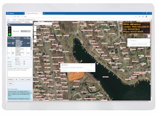
Multi-layered interactive maps can be displayed with Adept GIS to track
plan reviews and inspections.
Staff can generate customized on-demand reports.
Planning Department Management
Manage the life cycle of:
Developments
Projects
Activities
Structures, Floors, Units
Types, and Subtypes
Documents Images and Reports
Documents Markups, Versions and Online Site Plan submittals
Fees and Payments
Full Fee and Payment Account System
Standard Auto Fees
Miscellaneous Fees
Lookup Fees
Multiple Tender and Fees Items
Accepts all forms of payments and currency of choice
Inspections
Planning Reviews and Inspection system
Conditons and Approvals
Event Tracking
Contractors, Engineers, Developers and Architects
Planner Calendars
Workflow
Manage and support your tasks across your organization
Master, Folder, Tasks
Tigger supported actions
Department, Groups, User, and GIS Task Assignable
Works with all Plannning Activities and Inspection Tracking
Operations and Maintenance

GIS Data and Map Integration
The existing GIS maps created within your own GIS systems interface directly with Adept Enterprise ®, linking mapping and aerial imagery property information with property ownership data that is instantly accessible by Field Inspectors in real time. The Adept system pinpoints the specific location of project boundaries using GIS data and identifies the types of uses and facilities located along your project.

Contact Us today to find out how Adept Enterprise ® is the right software system for your organization.
System Requirements
Windows ®
- Windows 11
- Microsoft Edge, Google Chrome, Apple Safari, DuckDuckGo, Firefox, and Tor browsers are supported.
- Intel Xeon/Core i9/Core i7/Core i5 or AMD Ryzen/Opteron/Phenom processor(s)
- WHQL-64 certified
- 16 GB RAM min (32GB+ RAM recommended)
- 1GB free drive space for installation
- Hardware accelerated OpenGL 1.6 compatible graphics card with at least 512 MB RAM (OpenGL 2.2, or higher, compatible recommended)
- DirectX (used for audio processing only)